Plesir
pleasure, jalan-jalan dan kegemaran dan lain2
Tuesday, November 21, 2006
Height: 9,868 feet (3,008 meters)
Location: East Java, Indonesia, Asia
This mountain route is the longest one at Java Island. In the map, this route is almost 30 kilometres far. It's located at 3 different states, Probolinggo, Bondowoso and Jember. And all that state located in East Java Province.
There is a lot of peak at this mountain, but only two peaks whish usually climber visited. They are Argopuro Peak and Rengganis Peak.
There are two start point that usually used by climber who visited here. From Baderan or from Bremi. Baderan located at Bondowoso or Besuki and Bremi located at Probolinggo.
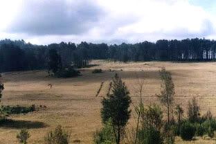
If we taking Baderan as the start point, we'll see a beautiful panoramas along this route. We'll see a tropical rain forest, and then long long savana, and may would make us bored besause we'll across along this savana almoust all day hiking.
But there is a few point of this route that we can take a rest here.
If we take form Baderan, after hiking about 6 hours we'll come to 1st water point (mata air 1)
and then from mata air 1 we'll come to mata air 2 (2nd water point) after 3-4 hour in hiking.
From Mata Air 2 we'll trekking to Cemoro Panjang taking about 1-2 hours. this may one of the hardest route.
And then after we reach Cemoro Panjang, we will come to Alun-Alun Kecil. From this point we will see a long trip of savana before comes to Cikasur / Alun-alun Besar. It's take at least 3-4 hours.
Cikasur
There is a lot story of Cikasur. Before 1945, this place became a Japan's aircraft landing, that hidden between hills. So the Indonesian soldiers could detect this place.
At this place, we usually could watch peacock, belibis, pigs, monkey at aerly morning or late afternoon. It's beautiful view's here, besides a small river down this camping area with it's fresh water and water salad on it.
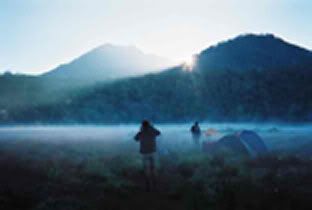
After here we should move to Cisentor (Aeng Poteh / air putih / White water area).This is could be our last camping point before reach summit.
And from Cisentor, we can go to the peak via Rawa Embik. If we take the right side of the route from Rawa Embik, we can reach peak of Argopuro.
And when we take the left side of the route from this place, we can reach Rengganis peak (in map it's named Welirang peak).
When we want to go back, we can choose 2 options. Back to Baderan (our start point) or continue to Bremi (our finish point later).
If we continue to Bremi, we'll pass Aeng Kenik (one of water point), and then Danau Taman Hidup (Life Garden Lake).
From Danau Taman Hidup, we can reach Bremi, our finish point in 3 hours
Taman Hidup
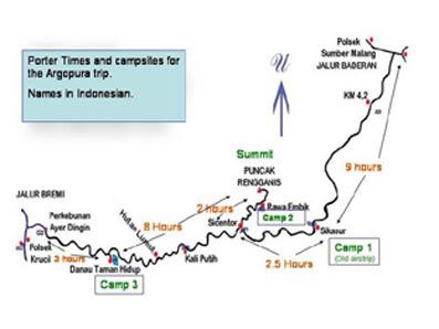
a simple route map
souce: http://www.summitpost.org/show/mountain_link.pl/mountain_id/3025
Location: East Java, Indonesia, Asia
This mountain route is the longest one at Java Island. In the map, this route is almost 30 kilometres far. It's located at 3 different states, Probolinggo, Bondowoso and Jember. And all that state located in East Java Province.
There is a lot of peak at this mountain, but only two peaks whish usually climber visited. They are Argopuro Peak and Rengganis Peak.
There are two start point that usually used by climber who visited here. From Baderan or from Bremi. Baderan located at Bondowoso or Besuki and Bremi located at Probolinggo.
If we taking Baderan as the start point, we'll see a beautiful panoramas along this route. We'll see a tropical rain forest, and then long long savana, and may would make us bored besause we'll across along this savana almoust all day hiking.
But there is a few point of this route that we can take a rest here.
If we take form Baderan, after hiking about 6 hours we'll come to 1st water point (mata air 1)
and then from mata air 1 we'll come to mata air 2 (2nd water point) after 3-4 hour in hiking.
From Mata Air 2 we'll trekking to Cemoro Panjang taking about 1-2 hours. this may one of the hardest route.
And then after we reach Cemoro Panjang, we will come to Alun-Alun Kecil. From this point we will see a long trip of savana before comes to Cikasur / Alun-alun Besar. It's take at least 3-4 hours.
Cikasur
There is a lot story of Cikasur. Before 1945, this place became a Japan's aircraft landing, that hidden between hills. So the Indonesian soldiers could detect this place.
At this place, we usually could watch peacock, belibis, pigs, monkey at aerly morning or late afternoon. It's beautiful view's here, besides a small river down this camping area with it's fresh water and water salad on it.
After here we should move to Cisentor (Aeng Poteh / air putih / White water area).This is could be our last camping point before reach summit.
And from Cisentor, we can go to the peak via Rawa Embik. If we take the right side of the route from Rawa Embik, we can reach peak of Argopuro.
And when we take the left side of the route from this place, we can reach Rengganis peak (in map it's named Welirang peak).
When we want to go back, we can choose 2 options. Back to Baderan (our start point) or continue to Bremi (our finish point later).
If we continue to Bremi, we'll pass Aeng Kenik (one of water point), and then Danau Taman Hidup (Life Garden Lake).
From Danau Taman Hidup, we can reach Bremi, our finish point in 3 hours
Taman Hidup
a simple route map
souce: http://www.summitpost.org/show/mountain_link.pl/mountain_id/3025
LINKS
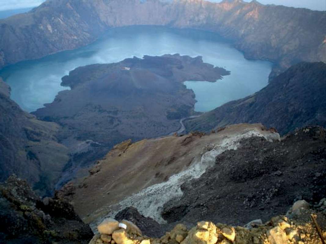
Mount Rinjani
Location: Lombok/West Nusa Tenggara, Indonesia, Asia
Lat/Lon: 8.42°S / 116.46670°E
Activities: Hiking, Mountaineering
Elevation: 12224 ft / 3726 m
Routes
There are several routes on Rinjani.
The two main routes are the following: from Sembalun Lawang on the eastern side, and from Senaru on the northern side. The two routes are quite different. The trail from Sembalun Lawang leads up through savannah and open mountain forest. The ascent from Senaru is a walk-up through dense mountain rain forest, which noticeably changes with the altitude.There are various ways of climbing Rinjani. The most rewarding is a combination of the two routes. On the first day you can go up from Sembalun Lawang to Pelawangan II (2,900 m ?), a place on the north-eastern part of the crater rim which is a good base camp (8 hours). On the second day you can start at 2 or 3 am, and ascend to the top, where you will arrive just in time to view the sunrise (3 hours). Make sure you arrive at the top before sunrise, not only to experience a beautiful sunrise but also to have the best chance of getting a clear view. Later the view is generally soon blocked by clouds coming up from the rain forest. From Pelawangan II to the summit the way leads up through volcanic scree. From the top you will go down again to the base camp and then you can descend to the lake, where you can spend the second night (5 hours, from the top). On the third day you can climb up to Pelawangan I (2,634 m), a place on the northern side of the crater rim, (2 hours), and descend to Senaru (6 hours). You can do it the other way round as well, but it seems better to climb the summit first and then relax at the lake and the hot springs.
Other routes:You can walk up to the crater from Torean, a small village near Bayan, on the northern side of Rinjani. The trail follows the stream that flows from Lake Segara Anak and the hot springs.You can also climb the south side from either Sesaot, Tetebatu, or from Pesugulan, a small village near Sapit. The last-mentioned route leads up to Pelawangan II.
wants more Here
